The Jöri Lakes
Fallen out of time and space
TEXT & PHOTOS: KARIN HUBER | TRANSLATION: NANE STEINHOFF
The scenery around the Flüela Pass in the Swiss Alps is barren and primordial. Rubble, stones, rocks, lichens. This bareness soothes the spirit and the soul. It opens up space for other things, for the new. “Sense of time and space get lost, you are, you live…” says Markus, a fellow hiker on a trip to the Jöri Lakes near Davos.
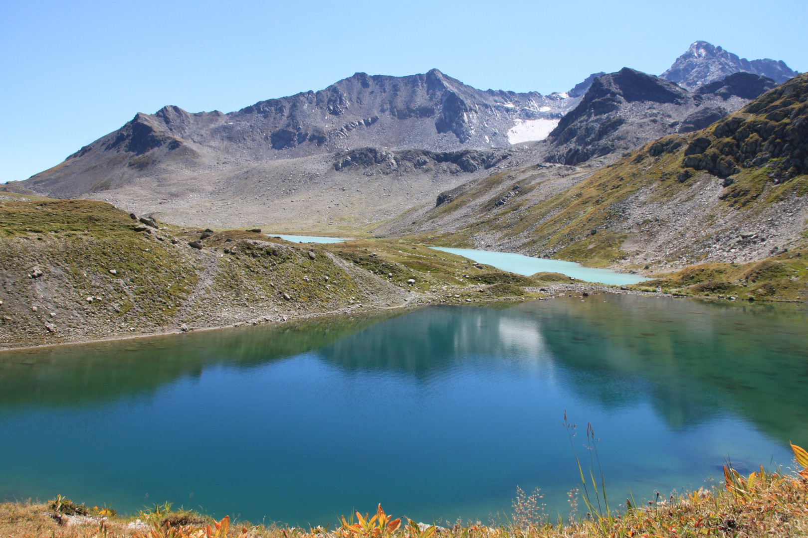
When one climbs up the last few metres, one stands on the ‘Jöriflüelafurgga’ alpine pass on 2,725 metres above sea level and finds everything just spectacular. We looked forward to this ‘wow’ moment for a long time. The vast, primordial high valley with the Jöri Lakes – the front one milky-white as if farmers have temporarily stored their cows’ milk here, the ones behind ink-blue; other lakes that lie beneath the ‘Jöriflesspass’ (2,561 metres) can only be seen when one hikes towards the ‘Winterlücke’.
Surreal, a different planet
The scenery is surreal: the mountains, the lakes, the surrounding green, the grey and brown stones, the sky blue above us. “This light,” murmurs hiking colleague Axel in awe. Mountain peak after mountain peak, the ‘Flüela Wisshorn‘ mountain (3,085 metres) and the southerly situated ‘Schwarzhorn’ mountain seem so close. Far away is the ‘Tödi’ mountain (3,614 metres), the Glarus Alps’ highest peak. The Jöri Lakes are fed by the ‘Jörigletscher’ glacier which has already retreated quite far. Someone explains that, between 2,200 and 2,800 metres, around 20 small and larger lakes can be found on three square kilometres. On the map however, we see less; some are probably not even marked on it because they are so small or dried up.
Ascent
The ascent to the saddle of ‘Jöriflüelafurgga’ is not difficult and leads us through an archaic stone and rock landscape with moss, lichens and autumnal colours. We feel like we have fallen out of time. Only the marmots’ warning whistles can be heard.
We started our hike in Davos. From there, the postbus drives to ‘Wägerhus’. At the beginning, we jump from stone to stone as mountain water tries to find its way across the hiking path. After around 150 metres in altitude is the junction; we choose the way towards the ‘Jöriflüelafurgga’ and the Jöri Lakes. The hiking path leads uphill in large turns – just like the Flüela Pass street that stays within our sight until right at the top. The path’s last section runs downhill again before we ascend the last few metres towards the ‘wow’ feeling.
Fish on 2,500 metres
Upon descent, the Jöri Lakes, besides which the Flüela Wisshorn’s slopes rise steeply into the sky, remain in our sight. But the path requires a great deal of attention. It is narrow, rocky, across several metres we have to make our way hand over hand along a steel rope. The rest remains steep but becomes more easily walkable again. It is green around the Jöri Lakes. The cows were there before us as the tracks reveal. Cotton grass gently sways in the wind. We keep hiking across a small bridge that leads us over the ‘Jöribach’ stream. It runs down towards the ‘Vereinatal’ valley and has its source in the largest of the Jöri Lakes. A few anglers swing their rods. Fish in the Jöri Lakes? “Sure, and not a few either,” they laugh and show us the creel that lies in the water with three caught Arctic chars. In any case, their dinner is taken care of…
For a short while, the hike takes us uphill again. The look back reveals that one lake has a reddish shimmer, it’s probably the iron oxide on the stones. A research team from Zurich also found iron sulphide and reduced, elementary iron there. Iron, as one of the researchers wrote on his blog, can be found in almost all oxidation levels, depending on which microbial environment it is located in.
Above the lakes, at 2,533 metres, the path splits once again. The landscape is changing, it becomes increasingly green, blueberry shrubs, long withered alpine roses, junipers, pastures, juicy mountain herbs. At first, the ‘Jöribach’ stream ripples mildly, then more and more water accumulates in the streambed, small waterfalls and water basins emerge in the midst of a wild and romantic, enchanting Grand Canyon miniature landscape. Here, four valleys meet: the Vereina, Vernela, Süser and Jöri valley. The ‘Jöribach’ stream and the Vernela stream also merge into the water-rich Vereinabach stream that splashes and turns into a torrential river.
700 metres lower: the Vereina railway
Close to the Vereina mountain lodge, at the end of the Alpstrasse, the RhB (Rhaetian Railway) trains between Selfranga and Sagliains blast through the 19-kilometre-long Vereina tunnel in 18 minutes 700 metres below us. Someone, according to narrations from the mountain lodge, once tried to walk along the contour line above the tunnel tube as close as possible – it supposedly took these “lunatics” 60 hours.
Those who still have enough stamina after the five-hour hike (without breaks) could keep on walking through the 14-kilometre-long wild-romantic Vereina valley with its waterfalls, small moors, shady mixed forests and arolla, mountain and dwarf pine trees towards Monbiel and Klosters. We sit down in the Vereina bus ordered in advance that conquers the altitude of 800 metres in 30 minutes and drives until Davos’ train station or Klosters.
Hiking trail infos:
– Walking time: four to five hours
– Altitude difference: ascent of 518 metres
Connections with public transport:

Subscribe to Our Newsletter
Receive our monthly newsletter by email