On the trail of Roman history: The German Limes Road
The long days of summer are ideal for exploring the landscapes and historic sites on the German Limes Road. The scenic driving route was established 20 years ago, running more than 700 kilometres between Bad Hönningen, by the bank of the River Rhine, and Regensburg on the Danube.
The picturesque tourist attraction is named after the Upper Germanic-Rhaetian Limes, once an imposing 550-kilometre barrier demarcating the edge of Roman authority in central Europe. A network of towers, earthworks and forts ran through German lands linked by a wall, in the west, and a palisade, in the eastern sector.
The term ‘Limes’ means ‘frontier’ in Latin, the Roman Empire’s common language. Letters scratched into bark by the styluses of auxiliary troops serving in the forts along its route described the posting as being on the Limes Germanicus—the German frontier. In 2005, the historic border was added by UNESCO to the ‘Frontiers of the Roman Empire’ World Heritage Site that already featured Hadrian’s Wall in northern England.

A fort, hidden in woodland at Holzhausen.
Germanic tribes were treated with respect and caution by Roman forces after winning a bloody victory at the Battle of the Teutoburg Forest in 9 AD. The Romans suffered at least 15,000 casualties in a defeat that became known as the Varian Disaster, after the name of the Roman leader, and is regarded by historians as the biggest military defeat ever suffered by the army of the Roman Empire. The consolidation of the Germanic frontier began in 85 AD. Soldiers cleared a strip of trees from woodland in the Taunus Mountains, today a region known for its spa resorts, and built towers from which they could observe the frontier.
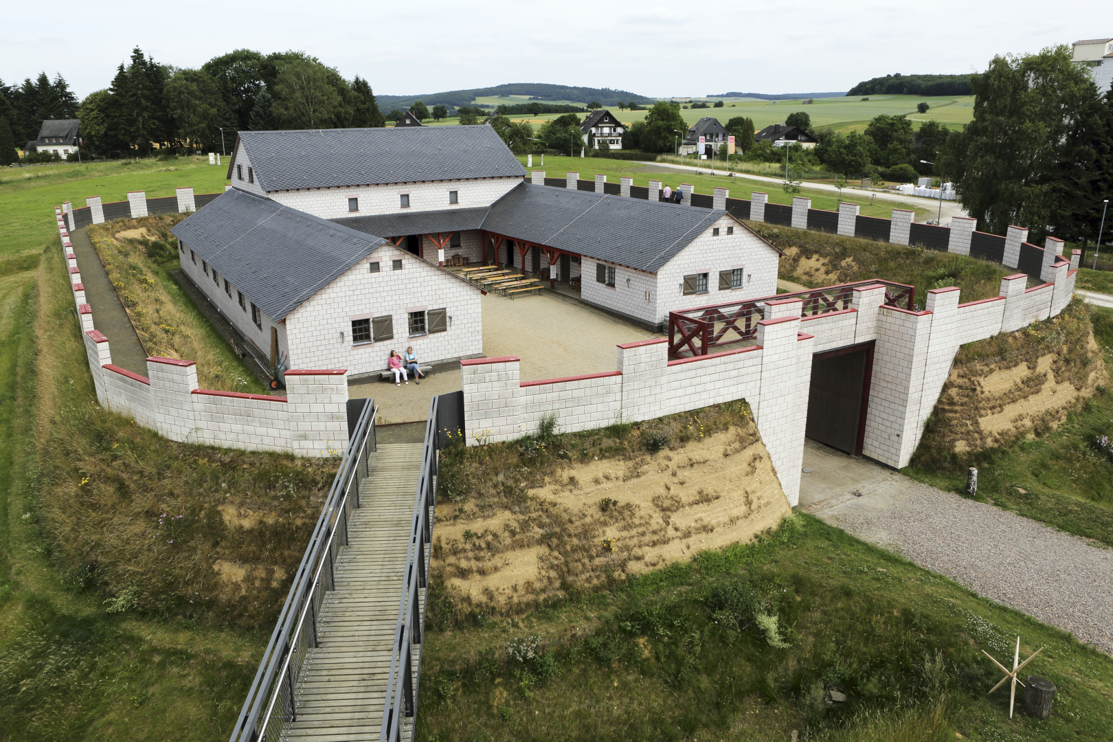
Over time, fortifications along the frontier were improved and expanded. In its heyday, during the late second century, the Limes Germanicus featured a series of forts and fortlets, plus more than 1,000 watch towers. Driving the German Limes Road gives visitors opportunities to visit faithfully reconstructed watchtowers at a number of locations, including Idstein and Mahdholz. At Pohl, in the Rhineland-Palatinate, a tower was recently rebuilt overlooking a fortlet that provides insights into the everyday life of troops stationed on the frontier. At the interpretation centre visitors can try on armour, enter barrack rooms and taste Roman style food in the café. Apicius, a gourmet who lived 1,600 years ago, collated recipes that allows modern cooks to recreate dishes ranging from lightly spiced sausages to an early take on goulash.

Food at Saalburg.
Archaeologists excavating along the Limes Germanicus have unearthed fragments suggesting that the wall was whitewashed. In an age when Europe north of the Alps had few stone structures, a gleaming wall would have represented a symbol of authority with significant psychological impact. Research also shows its gates allowed soldiers and civilians to pass, allowing taxes to be levied and sorties to be made into barbarian lands. Even during the height of the Roman era the frontier was deliberately porous.
Remnants of a triumphal arch stand protected from the elements inside an angular, contemporary glass building at Rainau-Dalkingen. The arch commemorates Emperor Caracalla’s successful military campaign of 213 AD. Yet, 50 years later, Roman authority in the region was waning and the once powerful empire was disintegrating; the Limes Germanicus was abandoned soon afterwards.

Remnants of an arch in Rainau-Dalkingen.
The stone-built wall, which once reached three metres high, became a source of pre-cut stone for people building homes and churches during the Middle Ages. This explains why the best-preserved forts, such as the one hidden in woodland at Holzhausen, are located well away from human settlements. Over time, the forest re-established itself and the purpose of the wall was forgotten. Its outline can still be seen as a ridge cutting through woodland. The contours of earthworks are clearly visible in places. The mysterious remnants were described as ‘the Devil’s Wall’ by the God-fearing farmers of the Middle Ages.
The Justinus Felsen in Aartal, a 30-minute walk into woodland, is the site of the inscription regarded as the oldest graffiti north of the Alps. The name Justinus is etched into the face of a vast rock, which archaeologists think could be the name of an auxiliary posted to frontier duty.

Saalburg.
Between 1897 and 1907 the fort at Saalburg, near Bad-Homburg, was reconstructed on the site of the original thanks to patronage by the German Emperor Wilhelm II. Modern archaeologists would disapprove of such a destructive practise. Nonetheless, the site has evolved into one of the most-visited locations along the German Limes Road. Volunteers and re-enactment groups meet at Saalburg on summer weekends to provide insights into life during Roman times, including demonstrations of weaponry and musical instruments.
The German Limes Road sweeps through forests, farmland and more than 80 towns in four states. The route is as much an insight into small town Germany in the modern age as it is about the history of the Roman Empire. Clearly signposted, drivers have the freedom to follow as much or as little of it as they wish.
TEXT: STUART FORSTER | PHOTOS: STUART FORSTER

The rebuilt tower in Pohl.

Subscribe to Our Newsletter
Receive our monthly newsletter by email